Knowle to Bordesley
The path continues to be good and there’s increasing traffic noise, the tall hedges mean there’s little to view and you reach a very pleasant cutting that is sliced by the M42 before Copt Heath Wharf. In addition to this automobile intrusion, planes can be seen landing and departing Birmingham International Airport or, as oldies call it, Elmdon. The path is now a bike track above the fields with attractive views of the motorway as you approach Catherine de Barnes. What a great name for a village, with its cricket pitch and desirable canalside residences. The Boat Inn is a short walk from bridge 78. The towpath improves where willow on leather resonates through a pretty cutting but after bridge 78A you enter the outskirts of Birmingham.
Luckily this is the posh bit and the birds sing as you pass large new developments until the semis take over at bridge 80. At times the path now resembles a motorbike scrambling circuit but even though urban sprawl surrounds the canal, it is quite peaceful. You wouldn’t guess that the giant Rover works were adjacent. Between Lode Lane (81) and Castle Lane (83) the cutting reaches about 50ft deep but more houses appear approaching bridge 84 at Richmond Road.
Nearby is Olton Reservoir, constructed in 1799 by French prisoners of war and extended in 1834, originally the canal’s main source of water holding 150 locks worth of the stuff. Keeping to the 380ft summit level which is maintained for 11 miles from Knowle to Camp Hill, you pass Olton Wharf, which is now an industrial estate and at bridge 88 enter the Second City, the UK’s largest local authority, ‘The World’s First Manufacturing Town’, ‘The Workshop of the World’ and ‘The City of a Thousand Trades’ - although that amount must have dwindled post-Thatcher - or, as the sign says opposite, ‘Britain’s Canal City’.
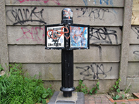
Although graffiti is everywhere, obliterating the first direction post (the second one further on has been stolen) and even sprayed on trees, you soon enter a quiet cutting with nesting wildlife that wouldn’t be out of place in The Chilterns. There is parkland on the right and the neat terraces of Acocks Green opposite. One thing you do notice is that there’s no boats, neither moored or passing, and hasn’t been for some time.
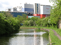
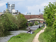
Next up are Clay Lane allotments and then the canal turns sharply to Yardley Road. Bus spotters will be aware that bridge 86A carries the iconic Outer Circle number 11, the longest urban bus route in the world, over 26 miles and two hours in length. Heading arrow straight for Tyseley and Hay Mills, rural cuttings are left behind as you pass the small and medium sized enterprises that kept the British economy going through a large part of the 20th century. They can be glanced through metal fences and barbed wire and at bridge 88c stands the mighty Birmingham Energy Recovery Facility.
Much of the surrounds are now the result of the dumping of clicker and ash from its predecessor the now demolished and wonderfully named Tyseley Destructor Works. After going over the River Cole you reach evidence of all that went wrong with the post war British economy. The Birmingham Small Arms company was established here in 1863 and armed the forces with over one and a half million guns in the Great War and 50% of precision weapons used during the second. Heavy bombing was therefore expected and subsequently delivered in November 1940 when 53 workers at the factory were killed. Although at one stage the largest motorcycle producer in the world, mis-management and under investment initiated its decline and fall.
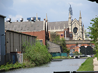
The BSA test site is now The Ackers adventure centre catering for a range of activities including archery, climbing, canoeing, orienteering and skiing. The landscape reverts to type after The Ackers (a nickname for the area) and the canal runs parallel to the A45, passing old wharfs and marshalling yards. On the left just before bridge 90 you can just about spot the old and new, a typically fine Victorian pub (The Marlborough) juxtaposed with the nearby mosque. After the canal straightens towards Camp Hill locks there’s the first sight of the city centre together with the impressive Holy Trinity church (1823).
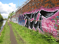
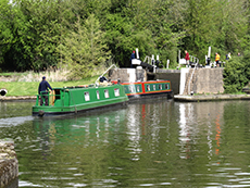
Just before the top lock you''ll pass what was the Grand Union Canal Carrying Co.'s Sampson Road warehouse, then the canal falls by 36 feet weaving through six locks. Building the Inner Ring Road meant re-aligning the canal and after taking an impressive chicane the landscape remains firmly industrial up to Bordesley Junction which is garnished with a huge amount of graffiti, barbed wire, metal sheeting and brick factory walls. Enquiring from an angler whether a freshly caught perch was edible the reply was, ‘Yes, but not out of here’ pointing to the stygian water. These and future locks are narrow as they weren’t widened during the 1930s due to expense and the fact that locks ahead were owned by a different canal company.
Luckily this is the posh bit and the birds sing as you pass large new developments until the semis take over at bridge 80. At times the path now resembles a motorbike scrambling circuit but even though urban sprawl surrounds the canal, it is quite peaceful. You wouldn’t guess that the giant Rover works were adjacent. Between Lode Lane (81) and Castle Lane (83) the cutting reaches about 50ft deep but more houses appear approaching bridge 84 at Richmond Road.
Nearby is Olton Reservoir, constructed in 1799 by French prisoners of war and extended in 1834, originally the canal’s main source of water holding 150 locks worth of the stuff. Keeping to the 380ft summit level which is maintained for 11 miles from Knowle to Camp Hill, you pass Olton Wharf, which is now an industrial estate and at bridge 88 enter the Second City, the UK’s largest local authority, ‘The World’s First Manufacturing Town’, ‘The Workshop of the World’ and ‘The City of a Thousand Trades’ - although that amount must have dwindled post-Thatcher - or, as the sign says opposite, ‘Britain’s Canal City’.
Although graffiti is everywhere, obliterating the first direction post (the second one further on has been stolen) and even sprayed on trees, you soon enter a quiet cutting with nesting wildlife that wouldn’t be out of place in The Chilterns. There is parkland on the right and the neat terraces of Acocks Green opposite. One thing you do notice is that there’s no boats, neither moored or passing, and hasn’t been for some time.
Next up are Clay Lane allotments and then the canal turns sharply to Yardley Road. Bus spotters will be aware that bridge 86A carries the iconic Outer Circle number 11, the longest urban bus route in the world, over 26 miles and two hours in length. Heading arrow straight for Tyseley and Hay Mills, rural cuttings are left behind as you pass the small and medium sized enterprises that kept the British economy going through a large part of the 20th century. They can be glanced through metal fences and barbed wire and at bridge 88c stands the mighty Birmingham Energy Recovery Facility.
Much of the surrounds are now the result of the dumping of clicker and ash from its predecessor the now demolished and wonderfully named Tyseley Destructor Works. After going over the River Cole you reach evidence of all that went wrong with the post war British economy. The Birmingham Small Arms company was established here in 1863 and armed the forces with over one and a half million guns in the Great War and 50% of precision weapons used during the second. Heavy bombing was therefore expected and subsequently delivered in November 1940 when 53 workers at the factory were killed. Although at one stage the largest motorcycle producer in the world, mis-management and under investment initiated its decline and fall.
The BSA test site is now The Ackers adventure centre catering for a range of activities including archery, climbing, canoeing, orienteering and skiing. The landscape reverts to type after The Ackers (a nickname for the area) and the canal runs parallel to the A45, passing old wharfs and marshalling yards. On the left just before bridge 90 you can just about spot the old and new, a typically fine Victorian pub (The Marlborough) juxtaposed with the nearby mosque. After the canal straightens towards Camp Hill locks there’s the first sight of the city centre together with the impressive Holy Trinity church (1823).
Just before the top lock you''ll pass what was the Grand Union Canal Carrying Co.'s Sampson Road warehouse, then the canal falls by 36 feet weaving through six locks. Building the Inner Ring Road meant re-aligning the canal and after taking an impressive chicane the landscape remains firmly industrial up to Bordesley Junction which is garnished with a huge amount of graffiti, barbed wire, metal sheeting and brick factory walls. Enquiring from an angler whether a freshly caught perch was edible the reply was, ‘Yes, but not out of here’ pointing to the stygian water. These and future locks are narrow as they weren’t widened during the 1930s due to expense and the fact that locks ahead were owned by a different canal company.
View Knowle to Bordesley in a larger map
Hover over bold italic text and photographs for extra information